|
Approx distance: 6 miles Approx time: 2 hours Highlights: Fine rural views, attractive bridleway across part of the old common, Bawdeswell Heath with its heather, bracken and fine trees for climbing and swinging on. A short but invigorating walk. Head for Foxley past the school and along the pavement past the Old Rectory on your left, and old police house on your right. Cross over the by-pass at the traffic island with care and turn left into Foxley West. A couple of hundred yards on at the crossroads turn left down Mill Lane. The house on the corner was once the Dog Inn and the main road to Fakenham passed this way. Going down Mill Lane you
can see a grand Georgian house over to your right. This is Foxley
Lodge, built originally as the Rectory. After a while there is a
large modern house on the right with a big pond.
.
The road suddenly turns left
through ninety degrees. The first plane is thought to have come down 50yds North of this bend. Old maps indicate this was once a crossroads.
If you look to the right towards the distant water tower, the hedgerow
and tree line certainly looks like an old boundary. It is in a straight
line with the Foulsham Road.
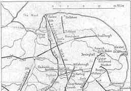
Continuing left towards the Billingford Road you pass Mill House which is built on to a former windmill. The busy main road is on the line of the Roman Road. It ran from Durobrivae near Peterborough, across the Fen Causeway to Denver, followed Fincham Drove and crossed Peddar's Way between Castle Acre and Swaffham, thence towards North Elmham and Billingford, to Bawdeswell and Jordans Green, and on to Smallburgh. It was a major East-West route and possibly continued to Caister or an important port since eroded by the sea.
Crossing over this road to
the lay-by you enter a delightful bridleway leading to Bawdeswell Heath.
This area was part of Bawdeswell Common before the Enclosure Act of 1808.
An old strip-field system lay either side of the lane. Occasional crop
marks indicate an earlier branch off the Roman Road heading south-eastwards
in the direction of the Wensum valley.
The entrance to the Heath at the bottom of the bridleway is very pretty. Once through the gate you can turn left or right and follow numerous paths round the perimeter through the bracken and trees, or carry straight on and cross over the middle to the Dereham Road.The centre section is very undulating, the result of small scale gravel extraction in earlier times. There is abundant heather, small oak trees, bracken and larger trees ideal for climbing and swinging on. It is in fact a very fine picnic spot, but you are more likely to find dog walkers and horse riders, or just find you have the place to yourselves. BMX and motorcycle riders have caused consternation by damaging some of the paths and creating jumps, but they are discouraged.Bawdeswell Heath Up to two hundred years ago
the village lay in the middle of a large Common stretching from Billingford
in the West and nearly half-way to Reepham in the East. The old Roman
Road, known as Common Lane, ran right down the middle of it. In the
year 1808 a private Act of Parliament caused the enclosure of the Common
Land around Bawdeswell, resulting in the gathering up of arable land into
very few hands.
Today Bawdeswell Heath Trust
, a local group of volunteers, look after the Heath. They carry
out conservation work to maintain it and restore parts of it that have
become overgrown. This involves, amongst other measures, clearing
bracken and small trees and replanting heather.
The route back to Bawdeswell unfortunately is on the main road so walk in single file. There is a way across Bylaugh Wood to the much quieter Elsing Lane but this is private land. Due to the fact that it is leased out to a third party, it is not possible for the moment to create a Permissive Path that way. The long brick wall along the main road, broken in places, was built around the Bylaugh Estate to use up the money that had been left for the sole purpose of building the Hall. You pass the remnants of three or four earlier tracks off to your right. Shortly after the Bawdeswell Lodge and the Shooting Box, there is a gated shady pathway. Was this the route of the lost Roman Road said to run along the border of the Heath and Bylaugh Estate, to Sparham Hole and beyond? Next there is The Drift with quite a collection of secluded dwellings of some age. On your left you pass a sewerage pumping station, taking all the fouls drainage of Bawdeswell and Foxley to the sewerage works next to Bylaugh church. The next track, Leeds Drift, went right through to Elsing Lane but has been ploughed up in recent times. The last lane on your right, just before the by-pass is Jotts Lane. There is a footpath here leading on to Elsing Lane, but it is too late to be of any use to us. Cross the main road and proceed
through the gap to the Old Dereham Road and Adam's Pit Nature Reserve and
you are nearly home.
|